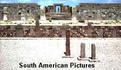
The
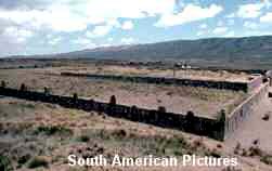
great stone structures of Tiwanaku date from about AD 100 and were being
developed and enlarged by an ancient race for almost six hundred years before
they finally declined sometime around the year 1000AD'
 So
runs the archaeological story drawn from evidence such as RadioCarbon dating,
analysis of gravesite materials and detailed comparisons with other central Andean
cultures. The styles of designs on the pottery have been especially important
in determining a sequence of events through recent history.
So
runs the archaeological story drawn from evidence such as RadioCarbon dating,
analysis of gravesite materials and detailed comparisons with other central Andean
cultures. The styles of designs on the pottery have been especially important
in determining a sequence of events through recent history.
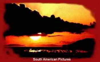
A
great flood? True or false? Although the deep covering of earth over the Akapana
and the Kalasasaya has never been clearly explained, the geological history is
understood. Long before the arrival of the people who built Tiwanaku the altiplano
or high plain of the central Andes was covered by two huge lakes. Over
the years these lakes have evaporated leaving traces of ancient beaches
in the surrounding mountains. The decline of the great lakes was gradual and their
remnants can be seen today as shallow salt lakes or enormous saltpans or salares
such as those of Uyuni or Coipasa.

The modern Lake Titicaca is the most northerly of the present day lakes and
it drains gently southward by a shallow river, the Desaguadero, which
in Spanish means quite literally a 'drain' .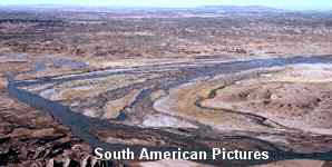 This river meanders for 450kms through a near featureless plain at an altitude
of approximately 3750 meters until it reaches the lake system of Poopo.
Within
living memory Lake Poopo was a significant wetlands area where many species of
waterbirds congregated. The past forty years have seen changes and Poopo has been
drying. One reason has been the silting of the Desaguadero as the water flow from
Lake Titicaca diminishes. Silt has accumulated naturally in the outlet of the
Desaguadero river where it enters Lake Poopo holding back the water to create
a totally new lake known as Uru-Uru. Today even that is drying and Poopo itself
has become a large mudflat with just a few pools of brackish water
This river meanders for 450kms through a near featureless plain at an altitude
of approximately 3750 meters until it reaches the lake system of Poopo.
Within
living memory Lake Poopo was a significant wetlands area where many species of
waterbirds congregated. The past forty years have seen changes and Poopo has been
drying. One reason has been the silting of the Desaguadero as the water flow from
Lake Titicaca diminishes. Silt has accumulated naturally in the outlet of the
Desaguadero river where it enters Lake Poopo holding back the water to create
a totally new lake known as Uru-Uru. Today even that is drying and Poopo itself
has become a large mudflat with just a few pools of brackish water
'Land Above the Clouds' by Tony Morrison and published in
1974 ISBN 233 95737 5 has a full account of the lakes, climate and wildlife.
To
see a simple map of the lakes and rivers 
click the winged figure |
Do
the people hold the clues?
Tales handed down through the generations are still told around firesides
on the altiplano. A rich folklore contains elements of a past great flood,
angry gods, the arrival of white gods from over the oceans and so on. These tales
were recorded as long ago as the sixteenth century so there are no doubts about
their origin. But the stories seem to conflict with the science.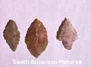 For example tiny arrow heads of basalt and quartz have been found along the edge
of some of the old beaches. These are not seen on the highest beaches and neither
on the lowest or around the present day shoreline. One conclusion seems
certain. People were there at some time during the age of the great lakes, perhaps
as long as ten thousand years ago. Anthropologists have traced the course
of the migration of the first tribes along an overland route from north America
revealing how tribes arriving in the Andes lived nomadically, hunting and gathering
wild food as they travelled. Tiwanaku came much later as the nomads began
to settle, to cultivate and domesticate some of the wild animals.
For example tiny arrow heads of basalt and quartz have been found along the edge
of some of the old beaches. These are not seen on the highest beaches and neither
on the lowest or around the present day shoreline. One conclusion seems
certain. People were there at some time during the age of the great lakes, perhaps
as long as ten thousand years ago. Anthropologists have traced the course
of the migration of the first tribes along an overland route from north America
revealing how tribes arriving in the Andes lived nomadically, hunting and gathering
wild food as they travelled. Tiwanaku came much later as the nomads began
to settle, to cultivate and domesticate some of the wild animals.
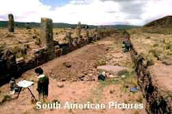
Who
were 'The Tiwanakans'? The early farmers lived simply but gradually drew together
as communities, possibly for protection from surrounding tribes and in a predictible
way some of these communities advanced more quickly. Around Tiwanaku the land
was good for agriculure and hand in hand with massive crop production the ceremonial
centre was built. Eventually Tiwanaku became a dominant culture in the south-central
Andes and its influence can be traced far and wide. 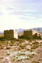 Then
quite suddenly it began to decline and the ceremonial centre
was virtually abandoned. No one knows why but perhaps it was no more than squabbles
among the leaders. Later history is a much clearer picture with accounts of two
powerful kinggdoms the Lupaca and Colla on the northwest and southwest corners
of Lake Titicaca with others of lesser importance scattered in the highlands.
Names such as Pacaje, Umasuyu, Charca and Canchi 'live on' as present-day political
divisions in the Bolivian highlands. Remains of these smaller groups exist in
many places and have been studied, largely by Bolivian archaeologists. Because
the area is vast and until recently has been largely inacccesible research has
been limited. But times are changing quickly and several good roads cross the
Desagadero river into the old land of the Pacajes. Burial sites and fortifiications
can be spotted from the road.
Then
quite suddenly it began to decline and the ceremonial centre
was virtually abandoned. No one knows why but perhaps it was no more than squabbles
among the leaders. Later history is a much clearer picture with accounts of two
powerful kinggdoms the Lupaca and Colla on the northwest and southwest corners
of Lake Titicaca with others of lesser importance scattered in the highlands.
Names such as Pacaje, Umasuyu, Charca and Canchi 'live on' as present-day political
divisions in the Bolivian highlands. Remains of these smaller groups exist in
many places and have been studied, largely by Bolivian archaeologists. Because
the area is vast and until recently has been largely inacccesible research has
been limited. But times are changing quickly and several good roads cross the
Desagadero river into the old land of the Pacajes. Burial sites and fortifiications
can be spotted from the road. 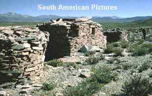
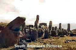
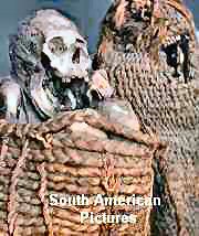
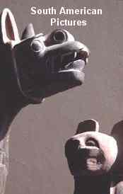
Chullpas Tombs locally known as chullpas dominate ridges and high
places seen by the ancient people as people as being closer to the sky and their
hilltop gods. Some chullpas were built of mud-sods or adobe, others were
of stone. Some were elaborate and other simple. Bodies of the deceased
were placed inside, usually knees to chin in beautifully made baskets.
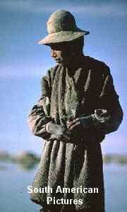
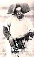
In
many ways these various tribes are regarded as the ancestor of the Aymara speaking
people who dominate the region today.The specialists in folklore have long known
of small differencess in customs and the legends handed down which are rapidly
being lost or simply becoming a single homogeneous 'altiplano culture'. Languages
and dress are changing too, and only old photographs serve to remind us of what
existed, even at the turn of the 19th century.
| Dates
and evidence on the ground hardly add up to Atlantis being set in the ancient
Andes. So what can account for the myths of 'The Flood'? Many questions
about Tiwanaku have yet to be answered and Part Three of this series will take
a look at the world and universe known to the ancient people. |
| With
special thanks to the late Alicia Posnansky and the late Brian Fawcett
|
|
|
| The
text and most of the images are © Copyright |
| For
any commercial use please contact |
| |
| THE
NONESUCH - FLOWER OF BRISTOL |
| AN
EMBLEM FOR ENTERPRISE | |