| Sacred
Centre  Today
there is little doubt that Tiwanaku was a major ceremonial centre and focal point
of a culture that spread across much of the region. The ancient people built a
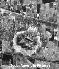
pyramid of crude stones known as the Akapana - That structure dominates
the bottom half of this aerial photo. When first recorded the pyramid was largely
covered with earth. After several decades of excavation some of the walls have
been uncovered and treasure hunters opened a depression in the top. This was built
originally to open towards the east. The dark line across the lower part of the
picture is the railway line from a lakeside port to La Paz, the Bolivian capital.
The rectangular outline just 'above and to the left ' of the Akapana is
a terreplein. known as the Kalasasaya. The lighter patch with an
indistinct outline 'above' the Akapana is where an excavated semi-subterranean
'temple' has been discovered. Other features are visible but most of the 'patches'
are fields. The upper part of the picture is crossed by the road from the
the village of Tiwanaku leading eastwards to La Paz. (taken from 'Pathways
to the Gods' by Tony Morrison 1978). Today
there is little doubt that Tiwanaku was a major ceremonial centre and focal point
of a culture that spread across much of the region. The ancient people built a
pyramid of crude stones known as the Akapana - That structure dominates
the bottom half of this aerial photo. When first recorded the pyramid was largely
covered with earth. After several decades of excavation some of the walls have
been uncovered and treasure hunters opened a depression in the top. This was built
originally to open towards the east. The dark line across the lower part of the
picture is the railway line from a lakeside port to La Paz, the Bolivian capital.
The rectangular outline just 'above and to the left ' of the Akapana is
a terreplein. known as the Kalasasaya. The lighter patch with an
indistinct outline 'above' the Akapana is where an excavated semi-subterranean
'temple' has been discovered. Other features are visible but most of the 'patches'
are fields. The upper part of the picture is crossed by the road from the
the village of Tiwanaku leading eastwards to La Paz. (taken from 'Pathways
to the Gods' by Tony Morrison 1978). Just
out of the picture to the bottom left is the site of the Pumapunku. This is another
'temple area' with many finely cut stones some weighing over 100 tonnes. Its position
to the south of the Akapana may have been important because it gave a good view
to a sacred mountain far to the east. Of course there is no certainty that this
was the reason as the ancient builders left no written records. All the legends
have been handed down through the generations. To
return to Part Two 'The Dawn of Time'
click the winged figure
|  Today
there is little doubt that Tiwanaku was a major ceremonial centre and focal point
of a culture that spread across much of the region. The ancient people built a
pyramid of crude stones known as the Akapana - That structure dominates
the bottom half of this aerial photo. When first recorded the pyramid was largely
covered with earth. After several decades of excavation some of the walls have
been uncovered and treasure hunters opened a depression in the top. This was built
originally to open towards the east. The dark line across the lower part of the
picture is the railway line from a lakeside port to La Paz, the Bolivian capital.
The rectangular outline just 'above and to the left ' of the Akapana is
a terreplein. known as the Kalasasaya. The lighter patch with an
indistinct outline 'above' the Akapana is where an excavated semi-subterranean
'temple' has been discovered. Other features are visible but most of the 'patches'
are fields. The upper part of the picture is crossed by the road from the
the village of Tiwanaku leading eastwards to La Paz. (taken from '