THE NEW AMAZONIA
| In
November 2012 Tony Morrison and John Forrest gave the Anglo Peruvian Society in
London an account of the InterOceanic Highway after its first year of completion.
With two speakers the presentation ran for 1hr 45 m and this page presents the
main points. Many of the illustrations used in the talk have not been included. The InterOceanic Highway: The missing link in the exploitation of Amazonia? For decades a road linking the Amazon heartlands to the Pacific Ocean was on the drawing board. It is now a reality with the opening of the Interoceanic Highway connecting southern Peru and its ports to the Brazilian states of Rondonia, Acre and beyond. Will this open up the rainforest to extensive soya bean farming and cattle ranching to supply Far Eastern markets or will it bring a range of economic and social benefits for the local people?
|
John opened the evening by looking back to the 1960's and the birth of the road plan.
Even more ambitiously Belaúnde had a grandiose plan to move the Peruvian seat of government from Lima to the Amazon. Some would say his plan was simply a dream based on the creation of the new Brasilian capital, Brasilia [built 1956- 60] and sited in the centre rather than on the coast. In the case of Peru almost sixty percent can be called Amazon land and most of it is sparsely populated - for Belaúnde it was a region to be opened-up and used. The newly completed InterOceánica Sur road linking the Pacific ports of Ilo, Matarani [see Islay near Mollendo] and San Juan de Marcona on the Peruvian coast is a marvel of planning and construction A consortium of Peruvian and Brasilian companies led the giant Odebrecht and Camargo Correa were responsible for the work financed in the order of 1.9 billion US Dollars by international development banks. The work was divided between the companies with each working on different sectors or tramos. Looking eastward towards the Amazon forest two routes lead over the mountains
Tramo 4 from the mountain town of Azangaro 27 kms almost due north from Lake Titicaca has a highest point of 4725m and Tramo 2 from Urcos near Cusco famed for its Inca remains reaches 4850 m . Both roads lead down the eastern Andean slopes through dense mountain rainforest recognised worldwide for its rich and probably unparalleled biodiversity. The routes join at Puente Inambari in the foothills 375 m above sea level and continue for another 179 kms to Puerto Maldonado, a town of about 92,000 [2005] and the capital of the Madre de Dios Region.
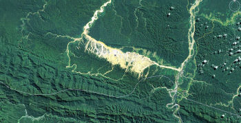
Puerto Maldonado has been connected by road to the highlands for many years but a journey from Cusco was usually counted in days. In the rainy season it could take a couple of weeks and sometimes the route was totally impassable. Now there are at least two bus services per day to Puerto Maldonado and weekly direct buses from Lima and São Paulo. Inevitably migrants are heading to Puerto Maldonado and towns along the road where they settle and work. One estimate says that there are 200 new arrivals per day. Farming along the roadside is still modest with families clearing and forest and planting crops such as yuca [manioc / cassava].The chacras [ cleared patches] are clearly visible on satellite images. Of
major concern is the unregulated gold mining in the lowland forest east of
Cusco. The area has always attracted gold seekers and groups of men eagerly wash
for gold along the riverbanks while others seek deposits under the earth. Men earn several dollars a day and it has been estimated that the annual production is about 30 tonnes of gold. To separate that gold about 30 tonnes of mercury and other chemicals are used. Environmentally it is a high price as the mercury and its residue ends up in the rivers. At the beginning of this year [2012] the Government imposed controls and miners are expected to register and work within a 500,000 hectare corridor bordering the river. Serious
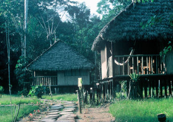
attempts to attract tourists began in the late 1970s and it is now a popular destination
for eco-tourists from around the world. The Tambopata river has more than a dozen
'lodges' - rustic hotels and on most days two flights arrive from Lima via Cusco.
All of the lodges provide tourist with a canoe journey on the Tambopata river
and a night in Fortunately large areas have been given some protection. The internationally renowned Manú National Park and World Heritage Area includes some headwaters of the Madre de Dios river. The Bahuaja Sonene National Park running next to the Tambopata National Reserve, the Amarakaeri Communal Reserve for indigenous communities and the Alto Purus National Park embracing the headwaters of the Purus river a major Amazon tributary This is how the limits are set out today but past experience reveals that the boundaries can be moved if deemed in the National interest. This was done in 2007 when the area of the Bahuaja Sonene was reduced by a third to permit future gas and oil exploration.
The people and their simple forest homes have been filmed from the air but so far no contact has been made on the ground. Other tribes live in the forest between the Alto Purus and Rio Las Piedras and they made news earlier this year when they were seen by tourists.
|
At this point Tony Morrison continued
It is hard to imagine that this huge river - it rises by at least ten metres in the rainy season - it is also hard to imagine that it is not navigable all the way to the Amazon. But on the way it joins two major rivers - here I'll just name them. The Beni comes in from Bolivia - one of it's tributaries is that polluted trickle that runs through La Paz - another is the Mamoré coming in from southern Bolivia with tributaries such as the Piraí the river of Santa Cruz de la Sierra - and these with many finally they become the Madeira, the Amazon's great tributary. This huge river then pours over series of giant rapids which to date have blocked the way to upstream navigation. The
road north from the Madre de Dios crosses one famous river - the Tahuamanú
- in fact, the town here - Iberia was The Tahuamanú eventually leads to the Amazon via the river Beni and the rapids. Here is the Tahuamanú near Iberia - taken from the road bridge. About At the border about 60kms onwards the road crosses the Acre river - also with a great rubber era history - but unlike the Tahuamanú with its route to the Amazon blocked by rapids, the Acre river flows to the Purus - It is shallow and without rapids. In high water the Purus is navigable for 2600 kms to the main Amazon - no wonder that in the Rubber Era small ocean going steamers were seen not far from here
After my first bus journeys I sensed that my wife Marion - who has anything but fond memories of mosquitoes and canoe travel didn't believe my stories . But recently she has joined me and seen what I am calling the New Amazonia as - indeed - it is very much part of modern Brasil
Sinop is now somwewhere in the middle of all these soya fields and has grown to over 110,000 people [2010] The name is an acronym for the name of the company that founded the town.
So
returning to the InterOceánica and the theoretical export route from
Amazonia via Peru's Pacific ports.
The canyon is over 2000m deep and the road goes down to the river and then out again with a series of hair-raising bends. The obstacle has been known for centuries and in Inca times a great bridge of ropes made from twisted dried grasses crossed the river. .. It inspired Thornton Wilder to write of the Bridge of San Luis Rey
About 1500 trucks would be required to carry the same as a Panamax grain carrier ship [Panamax = the largest size of vessel able to pass through the current Panama canal]
The US Department of Agriculture monitoring world prices for soya noted the rising cost of truck transport to get the soya to river ports - this rise was in part due to recently imposed Brasilian restrictions on driving hours.
By using barges any bulk products from Madre de Dios Region could be exported at low cost via the Amazon - much as rubber was in the 19th century. Of course the other two dams would be essential for simplifying the route - but money for products and money for infrastructure seem to go and in hand - at least in Brasil.
The area is largely pristine tropical forest and as John has said it is home to small pockets of forest tribal people - perhaps numbering no more than a couple of hundred who have had no real contact with Europeans since the rubber era.
And the Peruvian Government is not entirely against the road as long as it is controlled.... so with economics on its side and the need to establish a stronger Peruvian presence in Purus the road could get a go ahead.
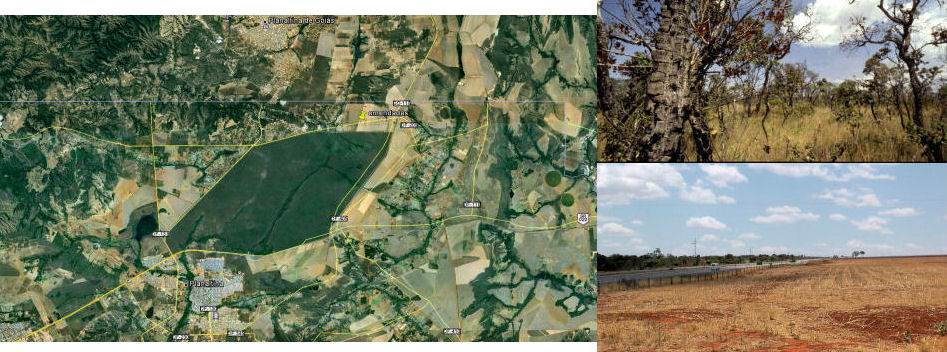
A month ago I was there again to see how apart from in the reserve the cerrado had survived - the reserve is remarkably well protected by guards and surrounded by a fence. But outside the fence huge soya fields sit cheek by jowl with a wilderness still home to wildlife much as we filmed just less than forty years ago. Two towns one with 76,000 people and connected by a major highway now abut the remaining 10,500 hectare protected area
|
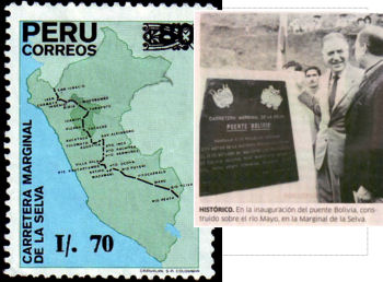 Peru's
President Fernando Belaúnde [1963 -1968] and a second term [1980 - 1985]
was an architect by training and a politician who pushed for road building to
integrate distant parts of the country. Belaúnde began the construction
of the Marginal Highway [Carretera Marginal de la Selva] a route along the forested
eastern flank of the Andes mountains and joining existing trans-Andean roads crossing
to the Pacific. Another Belaúnde plan was to link Peru with the Brasilian
road system then being developed in the Amazon basin.
Peru's
President Fernando Belaúnde [1963 -1968] and a second term [1980 - 1985]
was an architect by training and a politician who pushed for road building to
integrate distant parts of the country. Belaúnde began the construction
of the Marginal Highway [Carretera Marginal de la Selva] a route along the forested
eastern flank of the Andes mountains and joining existing trans-Andean roads crossing
to the Pacific. Another Belaúnde plan was to link Peru with the Brasilian
road system then being developed in the Amazon basin.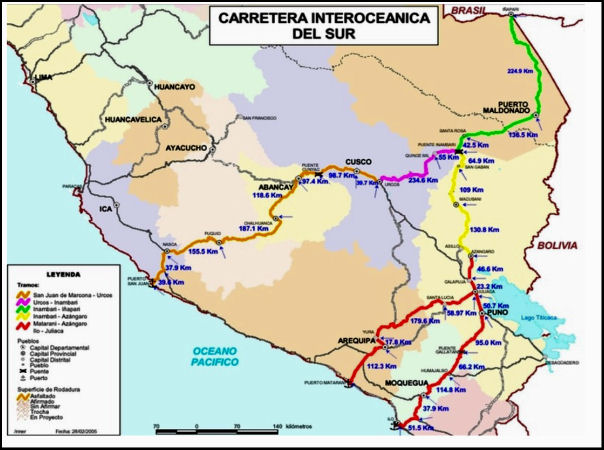

 One of the most notorious sites is Huaypetue in foothills about 10 km east of
the road near Santa Rosa. The scar is seen very easily on Google earth. Huaypetue
reached its peak in the early 1990s and now the prospectors are looking elsewhere.
One of the most notorious sites is Huaypetue in foothills about 10 km east of
the road near Santa Rosa. The scar is seen very easily on Google earth. Huaypetue
reached its peak in the early 1990s and now the prospectors are looking elsewhere.
 the jungle. But some do more with specialist guides for bird spotting or closer
to forest living the Baltimore Project for Rural Tourism offers accommodation
with families settled in the forest.
the jungle. But some do more with specialist guides for bird spotting or closer
to forest living the Baltimore Project for Rural Tourism offers accommodation
with families settled in the forest.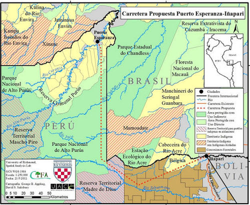 The
forests of the Alto Purus are almost pristine and the only significant settlement
is Puerto Esperanza with about 4000 inhabitants. There is a move amongst the population
to get a road built connecting with Inapari the frontier town. This proposal has
opponents as the forest close to the Brazilian border is home to an unknown number
of indigenous families.
The
forests of the Alto Purus are almost pristine and the only significant settlement
is Puerto Esperanza with about 4000 inhabitants. There is a move amongst the population
to get a road built connecting with Inapari the frontier town. This proposal has
opponents as the forest close to the Brazilian border is home to an unknown number
of indigenous families.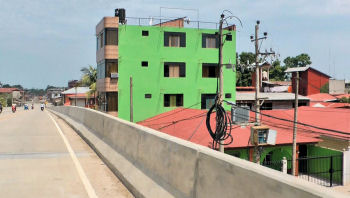 In
Puerto Maldonado the road is now a fact and the bridge, the 722 metre
Puente Continental - the longest suspension bridge in Peru has been open to
traffic for over a year. For the people its presence is inescapable as it the
access roads with massive concrete barriers dominate the centre of town. Such
planning would be impossible here in Britain.
In
Puerto Maldonado the road is now a fact and the bridge, the 722 metre
Puente Continental - the longest suspension bridge in Peru has been open to
traffic for over a year. For the people its presence is inescapable as it the
access roads with massive concrete barriers dominate the centre of town. Such
planning would be impossible here in Britain.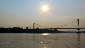 The
bridge has a fascinating story. It is the longest suspension bridge ever constructed
by the Austrian engineering company, Waagner-Biro. It was ordered back in the
late 1970s and when the parts arrived a shortage of cash and the lack of infrastructure
such as a road, left the parts sitting idle in a warehouse for about 25 years.
All that changed with an Peruvian-Brasilian accord to fulfil the long cherished
dream of an inter oceanic route.
The
bridge has a fascinating story. It is the longest suspension bridge ever constructed
by the Austrian engineering company, Waagner-Biro. It was ordered back in the
late 1970s and when the parts arrived a shortage of cash and the lack of infrastructure
such as a road, left the parts sitting idle in a warehouse for about 25 years.
All that changed with an Peruvian-Brasilian accord to fulfil the long cherished
dream of an inter oceanic route.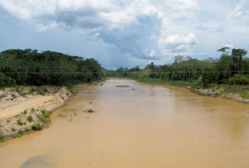 once
called Tahuamanú. Its history is tied to the late 19th Century and the
story of rubber when the near feudal control of the area was making fortunes for
absentee landlords . Some of you may recall the film and book Lizzie I
created for the BBC in 1985. Lizzie, a young Victorian lady spent the final days
of her short life on a rubber barraca , a collecting point downriver from
here
once
called Tahuamanú. Its history is tied to the late 19th Century and the
story of rubber when the near feudal control of the area was making fortunes for
absentee landlords . Some of you may recall the film and book Lizzie I
created for the BBC in 1985. Lizzie, a young Victorian lady spent the final days
of her short life on a rubber barraca , a collecting point downriver from
here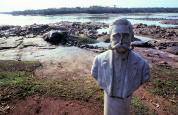 Rubber
was taken downriver around the rapids and goods imported from Europe went upriver.
Suárez became so powerful that ran his own private army - I mention all
this because in Amazonia today the cost of transportation is all important - remember
- Amazonia is much the same size as the continental USA
Rubber
was taken downriver around the rapids and goods imported from Europe went upriver.
Suárez became so powerful that ran his own private army - I mention all
this because in Amazonia today the cost of transportation is all important - remember
- Amazonia is much the same size as the continental USA 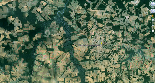 Sinop
- You will not find this place in older atlases - it was back in 1972
that the first roads were set out in the middle of the Mato Grosso - The Denser
Forest -that magical name for a wilderness so much talked about in the early
twentieth century
Sinop
- You will not find this place in older atlases - it was back in 1972
that the first roads were set out in the middle of the Mato Grosso - The Denser
Forest -that magical name for a wilderness so much talked about in the early
twentieth century 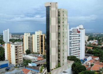 Cuiabá
on a river of the same name draining to the Plate system is the gateway to the
Mato Grosso - it is another city of a million or more. In 1950 the population
was just 62,000
Cuiabá
on a river of the same name draining to the Plate system is the gateway to the
Mato Grosso - it is another city of a million or more. In 1950 the population
was just 62,000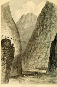 downhill all the way and there are formidable barriers to cross. One of the most
notable obstacles is the canyon of the Apurimac river flowing from the south and
reckoned as the Amazon's source.
downhill all the way and there are formidable barriers to cross. One of the most
notable obstacles is the canyon of the Apurimac river flowing from the south and
reckoned as the Amazon's source.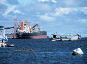 port
of Amazon port of Santarém - that's where Michael Palin began his journey
to see Henry Ford's old plantations in Fordlandia - from Santarém and from
Manaus 2,300,000 metric tons of soybean were exported last year.
port
of Amazon port of Santarém - that's where Michael Palin began his journey
to see Henry Ford's old plantations in Fordlandia - from Santarém and from
Manaus 2,300,000 metric tons of soybean were exported last year. 
 Here's
one set of locks at Tucuruí on the Tocantins river over in eastern Amazonia
where the system is working already. Two sets of locks give a lift of 75 metres
and the contructions totally more than the height of Big Ben [London's famous
clock tower] - you can even drive under the main lock. A six kilometre canal has
been cut to link the two sets locks and avoid rapids.
Here's
one set of locks at Tucuruí on the Tocantins river over in eastern Amazonia
where the system is working already. Two sets of locks give a lift of 75 metres
and the contructions totally more than the height of Big Ben [London's famous
clock tower] - you can even drive under the main lock. A six kilometre canal has
been cut to link the two sets locks and avoid rapids.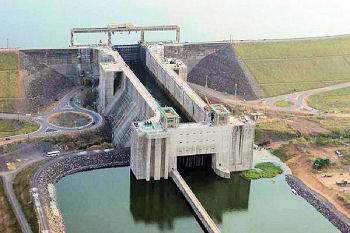
| | |||
| The
text and most of the images are © Copyright | |||
| For
any commercial use please contact | |||
| | |||
|